Geotechnical and structural engineers must take into account two fundamental characteristics of earthquake shaking: 1) how ground shaking propagates through the Earth, especially near the surface (site effects), and 2) how buildings respond to this ground motion. Because neither characteristic is completely understood, the seismic phenomenon is still a challenging research area.
Site effects play a very important role in forecasting seismic ground responses because they may strongly amplify (or deamplify) seismic motions at the last moment just before reaching the surface of the ground or the basement of man-made structures. For much of the history of seismological research, site effects have received much less attention than they should, with the exception of Japan, where they have been well recognized through pioneering work by Sezawa and Ishimoto as early as the 1930s [65]. The situation was drastically changed by the catastrophic disaster in Mexico City during the Michoacan, Mexico earthquake of 1985, in which strong amplification due to extremely soft clay layers caused many high-rise buildings to collapse despite their long distance from the source. The cause of the astounding intensity and long duration of shaking during this earthquake is not well resolved yet even though considerable research has been conducted since then, however, there is no room for doubt that the primary cause of the large amplitude of strong motions in the soft soil (lakebed) zone relative to those in the hill zone is a site effect of these soft layers.
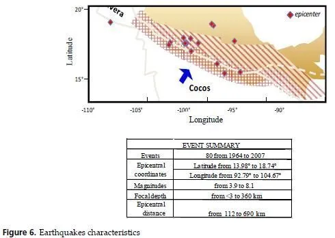
The traditional data-analysis methods to study site effects are all based on linear and stationary assumptions. Unfortunately, in most soil systems, natural or manmade ones, the data are most likely to be both nonlinear and nonstationary. Discrepancies between calculated responses (using code site amplification factors) and recent strong motion evidence point out serious inaccuracies may be committed when analyzing amplification phenomena. The problem might be due partly because of the lack of understanding regarding the fundamental causes in soil response but also a consequence of the distorted soil amplification quantification and the incomplete characterization of nonlinearityinduced nonstationary features exposed in motion recordings [66]. The objective of this investigation is to illustrate a manner in which site effects can be dealt with for the case of Mexico City soils, making use of response spectra calculated from the motions recorded at different sites during extreme and minor events (see Figure 6). The variations in the spectral shapes, related to local site conditions, are used to feed a multilayer neural network that represent a very advantageous nonlinear-amplification relation. The database is composed by registered information earthquakes affecting Mexico City originated by different source mechanisms.
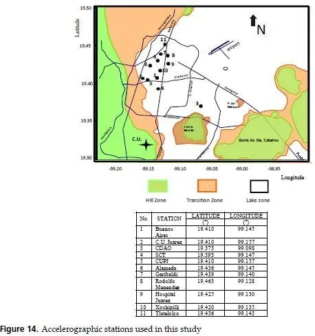
The most damaging shocks, however, are associated to the subduction of the Cocos Plate into the Continental Plate, off the Mexican Pacific Coast. Even though epicentral distances are rather large, these earthquakes have recurrently damaged structures and produced severe losses in Mexico City. The singular geotechnical environment that prevails in Mexico City is the one most important factor to be accounted for in explaining the huge amplification of seismic movements [67-70]. The soils in Mexico City were formed by the deposition into a lacustrine basin of air and water transported materials. From the view point of geotechnical engineering, the relevant strata extend down to depths of 50 m to 80 m, approximately. The superficial layers formed the bed of a lake system that has been subjected to dessication for the last 350 years. Three types of soils may be broadly distinguished: in Zone I, firm soils and rock-like materials prevail; in Zone III, very soft clay formations with large amounts of microorganisms interbedded by thin seams of silty sands, fly ash and volcanic glass are found; and in Zone II, which is a transition between zones I and III, sequences of clay layers an coarse material strata are present (Figure 14).
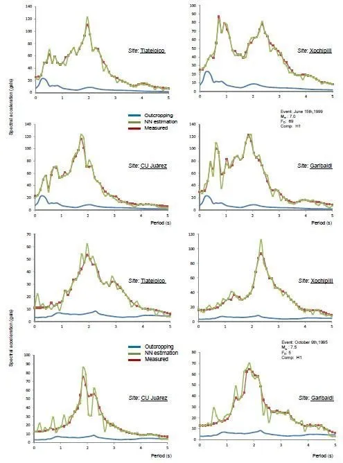
Due to space limitations, reference is made only to two seismic events: the June 15, 1999 and the October 9, 1995. This module was developed based in a previous study (see section 4.2 of this Chapter) where the effect of the parameters ED , FD and Mw on the ground motion attenuation from epicentre to the site, were found to be the most significant [71]. The recent disaster experience showed that the imprecision that is inherent to most variables measurements or estimations makes crucial the consideration of subjectivity to evaluate and to derive numerical conclusions according to the phenomena behavior. The neuronal training process starts with the training of four input variables booked: ED , FD and Mw .
The output linguistic variables are PGAh1 (peak ground acceleration horizontal, component 1) and , PGAh2 (peak ground acceleration, horizontal component 2) registered in a rock-like site in Zone I .The second training process is linked feed-forward with the previous module (PGA for rock-like site) and the new seismic inputs are Seismogenic Zone and PGArock and the Latitude and Longitude coordinates are the geo-referenced position needed to draw the deposition variation into the basin. This neuro-training runs one step after the first training phase and until the minimum difference between the Sa and the neuronal calculations is attained. In Figure 15 some results from training and testing modes are shown.
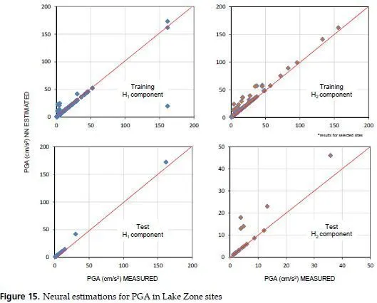
This second NN represents the geo-referenced amplification ratio that take into consideration the topographical, geotechnical and geographical conditions, implicit in the recorded accelerograms. The results of these two NNs are summarized in Figure 16. These graphs show the predicting capabilities of the neural system comparing the measured values with those obtained in neural-working phase. It can be observed a good correspondence throughout the full distance and magnitude range for the seismogenic zones considered in this study for the whole studied area (Lake Zone).
