When a survey line is longer than a chain length, it is necessary to align intermediate points on chain line so that the measurements are along the line. The process of locating intermediate points on survey line is known as ranging. There are two methods of ranging viz., direct ranging and reciprocal ranging.
Direct Ranging
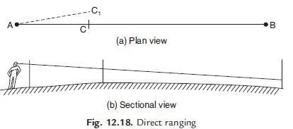
If the first and last points are intervisible this method is possible. Figure 12.18 shows the intervisible stations A and B in which an intermediate point C is to be located. Point C is selected at a distance slightly less than a chain length. At points A and B ranging rods are fixed. The assistant holds another ranging rod near C. Surveyor positions himself approximately 2 m behind station A and looking along line AB directs the assistant to move at right angles to the line AB till he aligns the ranging rod along AB. Then surveyor instructs the assistant to mark that point and stretch the chain along AC.
Indirect or Reciprocal Levelling
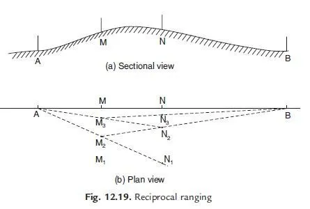
Due to intervening ground, if the ranging rod at B is not visible from station A, reciprocal ranging may be resorted. Figure 12.19 shows this scheme of ranging. It needs two assistants one at point M and another at point N, where from those points both station A and station B are visible. It needs one surveyor at A and another at B. To start with M and N are approximately selected, say M1 and N1. Then surveyor near end A ranges person near M to position M2 such that AM2N1 are in a line. Then surveyor at B directs person at N, to move to N2 such that BN2M2 are in a line. The process is repeated till AMNB are in a line.

Outstanding
very helpful ,, thanks
VERY HELP FUL