3.4 Resectioning
When a point has been set out and a proper monument of its position established, it is often prudent to carry out further checks to ensure that the mark is in the correct place. The process of finding the exact horizontal location of a single point with respect to other known stations is called resectioning. If the area is suitable for GPS work, the obvious way of carrying out this task is by means of differential GPS (see Chapter 7). Prolonged observation from the point after it has been established will then give a more accurate result than that obtained by the real time kinematic method which might have been used to set it out in the first place.
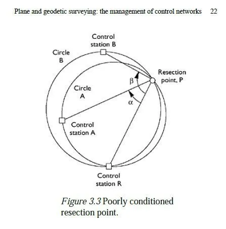
However, to guard against the possibility of a systematic error in GPS observations or data processing, it may be desirable to check the result by some completely independent means, i.e. the measurement of angles and distances with respect to nearby known stations. This may be as simple as using EDM to check that the two foundation points for a bridge are the correct distance apart, or it may require all the set-out points to be independently resectioned into the control network. To confirm the position of a point in two dimensions9 with some degree of redundancy, three or more measurements will be required. This could be any combination of horizontal distances and horizontal angles but note that measuring n horizontal angles from a point involves observing n+1 distant stations. Normally, resectioning is done by taking all relevant measurements from the point whose position is to be determined. If three control stations were used to set a point out initially, then two horizontal angles can be measured by observing those three stations, and one or more of the distances to the stations can be measured as well. Care is sometimes needed to ensure that the measurements which are taken are well conditioned i.e. that they will fix the position of the point to the best possible accuracy. With distance measurements, this is usually fairly obvious; if a point was resectioned by measuring distances to stations which were all nearly due east or west of it, there would be considerable uncertainty about its position in the north-south direction. In the case of angle measurements, the effect is more subtle, as shown in Figure 3.3. If the angle RPA is measured, a piece of information is obtained which will help fix the point P. Specifically, P is now known to lie somewhere on the circle labelled A, which passes through P, R and A. However, P could lie anywhere on this circle, and the same angle (α) would still be observed. Likewise, if the angle RPB were observed, P would be known to lie somewhere on circle B, which passes through P, R and B. If this was the same circle as circle A (i.e. if P, R, A and B all lay on a single circle) then nothing further would be known about the position of P, despite the additional measurement. If, as shown, B does not quite lie on circle A, then the position of P will be determined by the second measurement, but only to a very low degree of accuracy compared to the accuracy of the angle measurements. For instance, measurements taken from any point near P on circle A would yield an identical value for α and an almost identical value for β. Normally, the measurements taken to fix the position of P would be fed into a leastsquares adjustment program (see Chapter 10) to find its most likely location. If the measurements were poorly conditioned, this would become obvious from the results, which would show a large error ellipse for the position of P. The site would then have to be visited again to take further measurements, which is clearly undesirable. Surveyors should therefore be aware of the conditions under which measurements are likely to be ill-conditioned, even at the earlier stage of deciding where to position control points which might be used for subsequent resectioning.
3.5 Deformation monitoring
A common requirement for an engineering surveyor is to monitor the possible movement or deformation of a structure usually during the construction of a new building or tunnel nearby, but sometimes over a much longer period. This is achieved by attaching several small markers (studs or small adhesive targets) to the face of the building, and establishing a suitable number of control stations on the ground in the vicinity of the structure. Once the co-ordinates of the control stations are known (including relative heights), the positions of the markers can be found by observing them using a total station set up over the control stations. Typically, the horizontal angle between the marker and a known reference point would be observed, plus the vertical angle to the marker. If the height of the instrument above the control station is also measured, these two angles define a fixed line in space, on which the marker must lie. Defining two such lines (i.e. observing from two control stations) will precisely define where the marker must be, namely at the intersection of the two lines. In fact, there is even a degree of redundancy, as the two lines will generally not quite intersect each other the most likely position for the marker is then somewhere on the shortest link between the two lines. Generally, though, it is wise to obtain further redundancy, and further accuracy, by taking additional observations of each marker. These could include distance measurements to the marker as some adhesive targets are reflective, and so-called reflectorless total stations can operate without a conventional reflector at the target. Failing this, the control stations should be arranged such that each marker is visible from three stations.
Deformation monitoring is typically the most precise type of surveying, and often involves measuring the positions of points to the nearest 0.1 mm. All procedures therefore need to be carried out with special care, particularly the setting up of instruments exactly above station marks and measuring their exact heights above those marks. If a non-rotating optical or laser plummet is used to set the instrument up above its mark, then its accuracy should be checked at regular intervals (see Section 4.5). The following guidelines are also useful:
1 The control stations should if possible not be more than about 50 m from the markers,
to prevent unpredictable errors caused by the tendency of a light path to bend in the
atmosphere (see Chapter 11).
2 Particular attention should be paid to the error ellipses generated when the initial
positions of the markers are found through least-squares adjustment. Their sizes will
determine the smallest subsequent movement which can be detected with confidence.
3 A surveyor must consider (and possibly take advice on) the possibility that some of the
control stations may be affected by the same movements which affect the building. If
this is unavoidable (e.g. to comply with the 50-m rule, above), then additional control
stations must be established further away and the vulnerable stations re-surveyed
before subsequent measurements are made on the building.
4 The surveyor must also be clear on what types of movement need to be measured, when
setting up the control network. It may or may not be necessary to detect movements
which affect all the nearby terrain as well as the structure itself. If it is, then further
more distant control points must also be established. Ultimately, GPS provides the
best detection of movements of large areas of terrain, even including continental drift.
5 Deformation monitoring using adhesive markers can profitably be used in conjunction
with photogrammetry to monitor changes in shape of the structure (or rock face, etc.)
at points away from the markers. If the markers are visible in the photographs, the
position of any other distinguishable feature can be found using this technique see
Atkinson (2001).
6 For long-term work, it is advisable to have many more markers than necessary on the
structure, as some are likely to be lost with the passage of time, and of course there
should be enough control stations so that the reference co-ordinate system is not lost if
one or more of them is destroyed.


