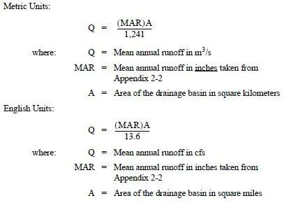
When available, published flow records provide the most accurate data for designing culverts and bridge openings. This is because the values are based on actual measured flows and not calculated flows. The stream flows are measured at a gaging site for several years. A statistical analysis, using the USGS Regression Peak FQ, is then performed on the measured flows to predict the recurrence intervals.
USGS, Ecology, local and state municipalities, and several utility companies work together to maintain gaging sites throughout Washington State. Flood discharges for these gaging sites, at selected exceedance probabilities (based on historical data up to2014), can be found in the following websites:
• StreamStats
• Freshwater DataStream data map
