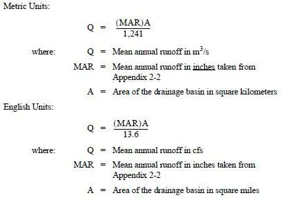
When the project is listed as a mountainous route, per the WSDOT Highway Log, or is over an elevation of 1,500 feet, the project shall consider snowmelt impacts. The PEO shall apply the method described in this section and consult the RHE, the local Maintenance Office, the local PEO, and historical data. Then in the hydraulic report, the PEO shall describe in detail what value (if any) was determined to most accurately represent snowmelt at a project location.
The first question PEOs should consider is whether snowmelt effects will impact a project. In particular, PEOs should check the snow record to determine the maximum monthly average snow depths for the project location. Snow depths can be found at the following websites or by contacting the RHE or State Hydraulics Office:
• Washington Climate Summaries
• Washington Snow Map
The following equation uses a factor of 5, developed from the energy budget equation by the United States Army Corps of Engineers (USACE), and available snow for eastern Washington cities to convert depth to snow water equivalent. This amount shall be added to the 100-year, 24-hour precipitation value when designing for flood conditions for rain on snow or snowmelt. The equation below should be applied only when the average daily depth within the month at a project location meets or exceeds 2 inches:
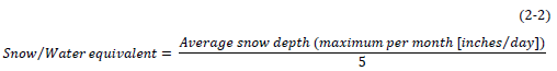
The snow/water equivalent shall not be greater than 1.5 inches.