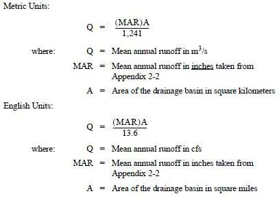
To determine the basin area, use the StreamStats web application, quadrangle maps, or ArcMap/GIS Workbench. These tools cannot be used in urban areas and all subbasins should be delineated by variation in soil and drainage characteristics.
All basins shall be field-verified to the maximum extent feasible. Select the best available topographic map (GIS or other approved mapping software) or best available data that cover the entire area contributing surface runoff to the point of interest. In areas under urban influence, flow paths do not always follow topography because of the presence of streets, buildings, and enclosed drainage (catch basins/pipes). In most cases, drainage patterns and catchment areas cannot be deduced from an in-office terrain analysis. Field verification of how the impervious areas and pervious areas are connected or disconnected to the flow paths may be required.
